

Jenny Thorsen 2021 Race Photos
The course runs entirely on trails (except for road crossings) and will traverse the Ice Age National Scenic Trail for 65 miles. The runners deviate from the Ice Age Trail when near the Nordic Trails at the start/finish and also near the Scuppernong aid station.
The course consist of 2 different out and back sections. You will find the trail to be about 80% wooded terrain, with the rest meandering through prairie or marsh areas. Part of the course will be a roller coaster of hills, with rocks and roots scattered about to various degrees. Other sections will be gently rolling with relatively smooth running surfaces. The pine sections give you that soft bed of pine needles that so many of us like to run on. Though the hills are not long and/or especially steep, they can take a tremendous toll on you if you attempt to run them. We have a total altitude gain of approximately 8,800 feet.
Link to:
“Kettle really is one of my favorite races and the reason I’ve come back to run it 7 times now. Coming from the desert I just love running the single track trails through the forests. Aid stations are well stocked (breakfasts are always awesome!!). It definitely has it’s challenges as far as the constant ups and downs go. You have to be patient right from the get go. The weather is a HUGE factor for us coming from the dry desert. The humidity zaps us desert rats. I love the storms that you guys have and ended up running through some ankle deep waters one year. One storm in the middle of the night was incredible....the lightening lit up the night. Fireflies are always so fun to see during the night too. Being a slow old broad I always get to enjoy the second sunrise which I love! ”
elevation gain/loss
100 mile: 8,801/8801 feet
100k: 5,584/5584 feet
38 mile: 3,217/3,217 feet
50k: 2,742/2,842 feet

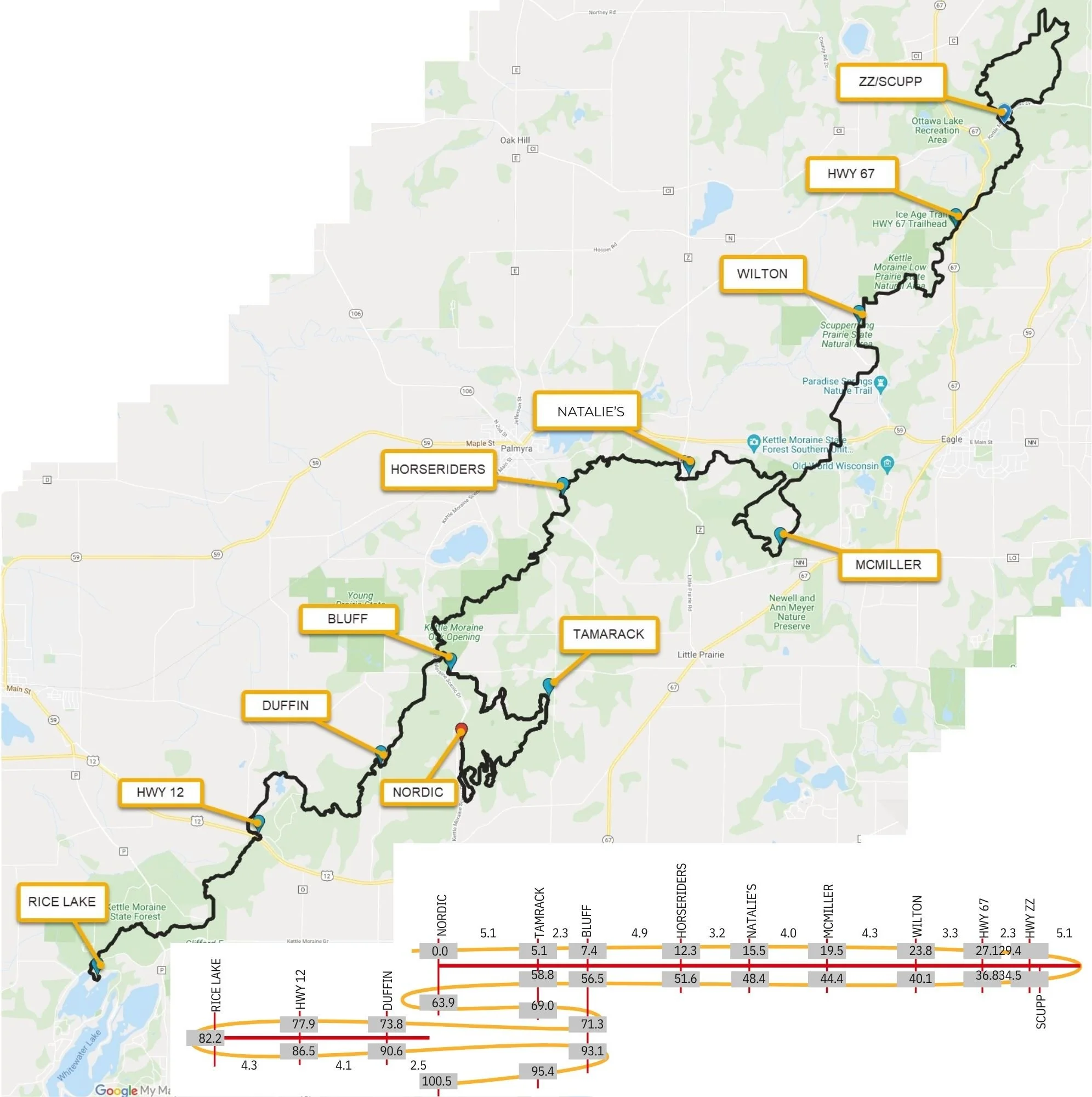
Map overview- The Department of Natural Resources has asked us to bypass Emma Carlin in 2020 and going forward.
Thank you Tim Branam for the GPX file
Please see aid station page for mileage at each aid station. This will help you understand the map.
100/100k runners: When you get to Scuppernong building you will be at mile 34. You will run past the Scuppernong building, cross the street to get to the aid station “Hwy ZZ”. Old timers may remember running back on the Scuppernong loop in the past. We DO NOT do that now because we now use the loop in McMiller which adds mileage to the course.
LINK TO 38 MILE FUN RUN SPREADSHEET
LINK TO 100 MILE TEAM RELAY SPREADSHEET
LINK TO Ultra Pacer the full 100 mile course
50k runners: start at Scuppernong, and do a loop that we will have marked for them in Scuppernong before heading back on the Ice trail to the finish line.
